Salkantay Inca trail To Machu Picchu
Overview
Inka trail six days through the slopes of snowy Salkantay and its’ altitudes, landscapes and ecosytems from Alpine to Cloud Forest. Backcountry trekking, visiting isolated farmes villages and quechua speaking peoples, on this amazing recovered Inca Trail full of archaeology, and dramatic scenery and the extra days for explorations of Machu Picchu
Difficulty of the trek: easy to moderate , good physical conditions.
Day 1: Distance: 12km- Altitude: 3553 to 4000 mts-hours 5-camping 4000mts.
Day 2: Distance: 12km- Altitude: 4000 to 4880mts- hours 8 -camping 3800mts.
Day 3: Distance: 16km-Altitude: 3800 to 2900mts-hours 8- camping 3850mts.
Day 4: Distance: 15km-Altitude: 3850 to 4221.3950 mts-hours 8 camping 3650mts.
Day 5: Distance: 10km-Altitude: 3650 to 2450 mts- hours 8- hotel 2450mts.
Day 6: Distance: 7km-Altitude: 2450 to 2060 mts- hours 6-Cusco hotel 3300mts.
Ecosystems: Scrub bush vegetation, andean semi dry forest, cloud forest, inter andean valleys. grass land, alpine, glaciers.
Highlights: Some Inca remains. High biodiversity, flora, fauna. Ancient Inca road, sacred mountains, amazing landscape.
Climate: The temperature varies in between below cero ºC to 2ºC,morning ,night to 20ºC,middle day to 25ºC day.mountain weather sunny to cloudy,windy.
The Inca road system called Capac Ñan (beautiful road or Great Inca road) it was the most extensive and complex ancient system in the new world. It is believed that this main road built it by the Incas was the main net work system that connected the four cardinal points in this part of the world. This sacred road was also part of the Inca empire high way of the Tawantinsuyo( the empire of the four corners).Chinchaysuyo(the north region,Contisuyo( the south region),Collasuyo (the west region) and then the Antisuyo( the east region )ending in the jungles of the unexplored Amazon
It use to run from south to north and from west to the east parts of the Andes with several primary and secondary roads that were connecting several sacred places, Inca cities, shires and administrative places as well military stations.All of them with great scale, beauty and functions, providing also all kind of sources for the people, helping the redistribution and spreading around the messages of the Incas, carried by Inca runners who where coming from the capital Cusco. The Capac ñan was a great web and work system with all the communication well organize with imperials and government messages and member in duty, used by the Inca people .In this way the Incas achieve a well organize empire and only with one language, one religion and one culture ,The Inca culture.
The Capac ñan covered a distance of over 40 thousand kilometers of primary and secundary roads made it by the Incas or added to their sistem from preInca civilizations and over 3000 kilometers long in a territory filled with one of the longest mountain range called the Andes over 9000 kilometers long, one of the densest jungle in the world the Amazon and one of the dries places in the world the dessert of Peru and Atacama. With elevations in between 100 to 5000 mts providing access to different ecosystem and territory estimates in over 5,000,000 square kilometers of territory, where the Incas built and crossed mountains valleys rivers and glaciers. The main road of the Incas was also beginning in the great capital of the Inca empire Cusco or Qosqo (navel of the world).According with the evidence found in this capital .There was the four main roads beginning in the sacred plaza of Aukaipata in the heart of the Inca capital city and used to go to the four directions of the empire ending in the places like the jungle and the high plateau of the Andes. Others covering valleys and then deserts ending close to the ocean.
It went in to places like Ecuador and Colombia in the north .as well to places like Bolivia, Argentina and the deserts of Atacama in between Peru and Chile. To access to those Inca roads it was mandatory to get permissions because many of f those Inca roads were used by members of the high classes and soldiers as well many representers of the government in duty. In some bridges taxes where charged as well many messagers were running through stations to deliver the messages that were connecting the different places.
The most spectacular and scenery road is found near Cusco that connects some sacred cities like Machu picchu, Choquequirao, Vilcabamba, Vitcos, Espiritu pampa.as well Sacred mountains called Apus like the Mythic Ausangante (6384 mts) and the Salcantay (6221mts).Finally some of those Inca trails are connecting communities in the area of Lares and the sacred valley ending some of the in the jungles of the department of Cusco.
itinerary
DAY 1 – Trekking Challacancha to Salkantay pampa
From our lodgings in Cusco, we drive northeast passing small villages and valleys to reach Mollepata, a little town at 2,745 meters. Then about 90 minutes further, we arrive at the trailhead, Challacancha at 3,353 meters. At this point we rendezvous with our expedition staff and pack animals. Salkantay comes here as we hike about 3 hours to the Humantay lake where we will see a beatiful view of the migthy Humantay snow capped at 5900 mts with a beatiful lake with cristal and turqoise waters here as we hike in Paramo over grasslands then, stoping for lunch and a beautiful view of the Peak of Salkantay at 6,271 meters. After a light lunch and short rest, we hike upwards on gravel and dirt trails, covering 7 km to Salkantay Pampa at 4000mts. This plateau, at 4000 meters, is close to a glacial moraine, wide open to the elements and tremendous views. The beautiful trail goes along the Salkantay river with the views of the Salkantay peak ,Humantay peak and the moraine to our camp. While walking this trail we have the chance to see wildlife in the scrub bush vegetation and grassland ecosystems with some bushes like Chillca(bacharis peruviana)Ichu grass(stipa ichu).As well if the time is right the Andean Condor(vulture gryphus) and the black chested buzzard eagle(geranoaetus melanoleucus).We will camp with spectacular views of the Salcantay Mountain. This is our spot for dinner and overnight camping.
DAY 2 – Salkantaypampa to Canal Inca
We get an early start today, so we can make the first pass, the Abra Inca Chiriasca at 4,880 meters, in about 3 hours. El Apu Salkantay looms even closer now and feels massive as reflected in glacial tarns and lagoons. We walk on inter-valley geological deposits, gravelly sections, and some stone steps. We stop for lunch ear in the paramo, or high alpine tundra, close to other glaciers. We continue trekking where few other “Inca Trail” visitors have walked, through different “Elfin” forests and warmer inter-Andean valleys, for about 2 hours until we reach the next campsite, Canal Inca 3800mts The Incas built an enormous retaining wall along the river for agriculture that is still tended by a small Quechua community of potato farmers. We’ll also see Chillca bushes, Bacharis Peruviana and ‘tanning’ trees, Caesalpinia Spinosa, also maybe birds like Plumbeous Sierra Finch, Phrygilus Unicolor, and Southern Yellow Grosbeak, and perhaps Pheucticus Chrysogaster, in the epiphytes and bromeliads family.
DAY 3 – Canal Inka to Llulluchapampa
About 2 hours of hiking today brings us to an original Inca trail, with sections of incredible stone work and we continue downward along the Pampacahua River to an Inca Administrative Tambo, at the confluence of three valleys, “Paucarcancha”, at 2,895 meters. Mid-day we arrive at the village of Wayllabamba for lunch. With hardly any change in altitude we cross different environments, some may enjoy a jump in the river. Wayllabamba is a control point for “The Inca Trail”, we meet our muleteers and fresh porters from Quechua families, we get official permission and documents so we can proceed to Machu Picchu. There will be a farewell ceremony and we leave for a 3 hour hike along the beautifully worked trail with stairs carved into the granite, ascending to one of our highest camps at 3505 meters, Llulluchapampa. With changes from cloud forest to cloudy puna, this is close to the habitat of the Andean Spectacled Bear, Tremarctus Ornatus. In this forest of mainly Unca trees, ferns, lichens and bromeliads are abundant too, maybe we’ll find the Wiñay Huayna orchid, “Forever Young”, Epidendrum Secundum, and “Molle” Pepper trees, Shinus Molle used by the Incas for mummification. Cloud forest birds of many different families abound such as hummingbirds, tanagers, flycatchers and maybe mixed feeding flocks. At our paramo camp there is little obvious plant variety under the view of the 5,464 meter tall Apu Huayanay. If it is a clear night, it may get very chilly and there will be countless stars.
DAY 4 – Llulluchapampa to Phuyupatamarca
Today is the hardest part of the route, an abrupt and steep ascent stretching only 2km and taking us about 2 hours, to Warmi Wañusta, the “Dead Woman’s Pass” at 4,200 meters, yikes! After resting within view of the majestic Apu Veronica at 5,832 meters, and over to Abra Runkurakay, we descend to 3600 meters into the valley of Pacaymayu. There is more beautiful Inca stone work stairs and we may see more orchids like Odontoglossum Mystacinus. Going up again to the third pass and Inca control point, Runkurakay at 3,970 meters, we pass the Black Lagoon, Yanacocha, and stop for lunch below at Chaquicocha. After lunch we’ll explore Sayacmarca, an intricate semi-circular complex with enclosures at different levels, narrow streets, liturgical fountains, patios and irrigation canals. Along this climb we can really appreciate the magnitude of the Incas’ stonecraft, held against cliff sides and perfectly cut to fit into multilevel ravines. We arrive at camp near an Inca settlement at 3,700 meters, Phuyupatamarca or “above the clouds”. During dinner at sunset, we will have exquisite views of Apu Salkantay, closer to Humantay at 5,900 meters and Wakay Willka, 5,365 meters.
DAY 5 – Phuyupatamarca to Machu Picchu
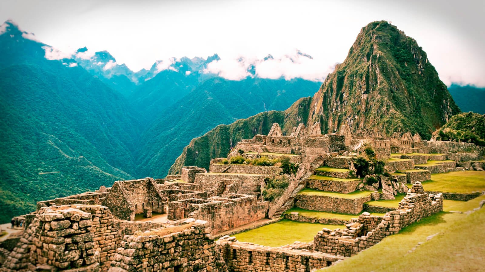
Continuing on “The Inca Trail” mainly downhill on more granite stairs, it is only about 5 hours more to Machu Picchu. We can visit another archaeological sites, Wiñay Wayna, second in size only to Machu Picchu on the Inca Trail, an Inca religious retreat and resting place for their Royal Courts. There are more Cloud forest species of bromeliads and orchids, like Bamboo orchids, Sobralia Dicotoma, Walnut and Coral trees. We may see the native Inca Wren, “Thryothorus eisenmanni”. At the Sun Gate, “Intipunku” at about 2,950 meters, we have a light lunch with spectacular afternoon view of Machu Picchu from above. This is our first encounter with the Sacred City of the Incas. After taking pictures and sensing the inspiration of this mystical site, we go by bus down to the town of Aguas Calientes. After checking into the hotel, there is time for dinner and an optional visit to the hot springs.
DAY 6 – Machu Picchu
Getting up at sunrise will allow us the best opportunity to see Machu Picchu before the crowds arrive. After a two-hour detailed tour,
Machu Picchu is situated at the beginning, or “eye brow”, of the cloud forest. This allowed access to different altitudes, each with unique ecological conditions. The crops found at Machu Picchu include different varieties of corn, chilies, quinoa, tomatoes, trees, potatoes, suggesting that this was a good place to acclimate and domesticate species from the high and low jungles that later would be successfully introduced into the hanging valleys and elsewhere.
Original discover by Agustin Lizarraga a Peruvian local from Cusco who inhabit a farm and explorer who discover Machu picchu in 1902.Nine years after Hiram Bingham rediscover Machu picchu in 1911.
This small valley was suitable for the building of temples and astronomical observatories,plazas,palaces, streets, utilitarian and functional buildings,ceremonial places, granaries, store houses and terraces for agriculture, Inca roads.
By analysis of soil, seeds, wood, and bones, Carbon Dating situates Incas in the area during the mid-1400s to mid-1500s. Machu Picchu was built by the Inca number 9 who named it “Pachacutek” or “Cusi Yupanqui”. Throughout the site, there is fine masonry and beautiful stonework, all of which is done without mortar. Construction used outside sources for laborers and two large granite quarries nearby. It is believed that the site was occupied by royalty and dignitaries, and that it was visited by the Inca and his entourage or royal court. Even though it was never quite completed, local scholars and historians believe that within a mere 100 years Machu Picchu was built, inhabited, and abandoned.Several roads connect to bring pilgrims and essential supplies to Machu Picchu, the site of temples and astronomical observatories dedicated to the sun, moon, stars, the universe, the mother earth “Pachamama” and the creator “Wiracocha”.
All these beautiful buildings were occupied by royalty, nobility and important people and their entourages. These were palaces, religious retreats, plazas, ceremonial places, astronomical observatories and they also served as military stations, store houses, granaries, and terraces for farming, all connected by Inca roads. Construction included existing rock, the small valley itself, and the mountain. Fine masonry and well carved, well-polished stonework, all assembled without mortar. The work was done by laborers from elsewhere who used ramps, rollers, and manpower.
We have option either to hike up Huayna Picchu, the peak in the background of the famous image of Machu Picchu, about 2 hours round trip with passes, or to climb the summit of the sacred Machu Picchu Mountain overlooking the entire area, about 2 1/2 hours. Alternatively, we can visit the Temple of the Moon. Afterwards, we will meet back up in the town of Aguas Calientes where to tour more or relax in the hot springs. Finally, we take the train back to the city of Cusco.
Includes
We Provide and Include: Itinerary transport roundtrip from Cusco-Licensed, Bilingual, history and naturalist Tour Guides-All Itinerary Meals, including vegetarian & snacks, Safety orientation and Equipment for optional activities-First Aid kit and Oxygen-Tour specific Sleeping bags, air mattresses and Expedition grade tents-Dining tent, Cook & Services- Porters,Llamas,Mules Horses for tour outfitting, wrangler staff, and emergency or back-up horse-Ecological, portable toilets-All Entrance Tickets-Bus up and down for Machu Picchu-Pre-purchased Return Train connections to Cusco.optional hikes in Machu picchu and Huayna picchu mountains and the Intipunku Inca trail.
Note
We can recommend the best and more comfortable hotels or we can take care of the reservations for you.
For adjusting to tour altitude, we suggest one day tours like the Sacred Valley hike,one day River Rafting before the Apurímac River and the City Tour of Cusco hike. As Guides we offer 100% Gauranteed Information, for your sensibilities – about the best specific hotel rooms and services around Peru, like extra windows and other amenities.
What to bring
This is a list designed to advise you what equipment is appropriate to bring according to the weather conditions predominating at the time of your trip:
Jeans and other pants are good as well.as well any clothes that cover the request of being water proof or resistance to water or cold are fine as long they are resistance to the conditions are fine.
- Flashlights (at least one headlamp among them).
- Sun Block; Insect Repellent.
- Towels (Small; cotton and hygienic).
- Rain Gear (Pants and Jacket)
- A couple of pairs of socks, perhaps even an extra pair.
- One pair of trousers for the evening plus two more pairs for trail use (zipp-offs).
- Sandals for River OR DRYSHOES.ASWELL use or CAMP OR HOTEL use (Teva types).
- Low ankle height hiking shoes or regular hiking boots (check the season).
- Reading material.
- Binoculars (always useful regardless of season and activity).
- Bathing Suit.
- Water Bottle (I liter capacity).
- Good Sun glasses, perhaps two sets.
- A bandana for neck protection.
- A couple of sets of underwear (perhaps an extra pair).
- Camera and plenty of film.
- Passport (plus a couple of Xerox copies).